General Properties: Common
Settings
All of the properties specified within this section of the General
Basemap Properties dialog are stored in the windows registry. This
means that changing the property will affect the display for all
projects, but only for the current user.
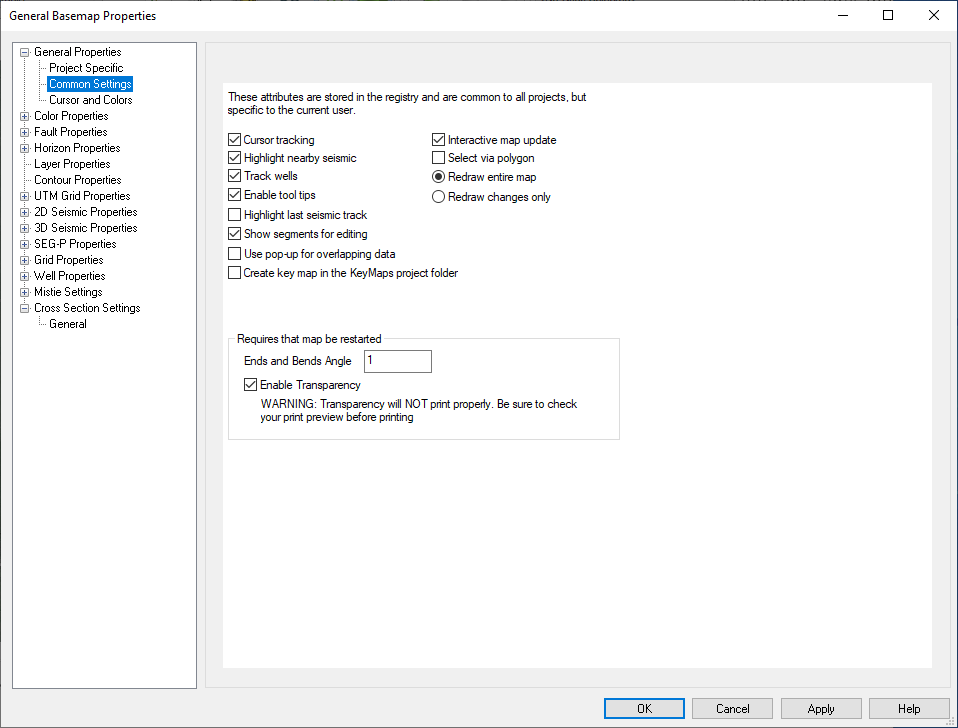
Cursor tracking: This enables and disables the tracking of the current cursor position at the bottom of the map. In projects with many 2D lines, this option may cause the map to slow down when selecting data for display. Turn this off to improve interactivity.
Highlight nearby seismic: Enables and disables the highlighting of the nearest seismic lines and wells. If enabled, the piece of data closest to the cursor will be highlighted in the "Line Editing Color" [see below].
Track wells: Enables and disables tracking for wells. Like cursor tracking, this can improve the interactive on the map when thousands of wells are present.
Enable tool tips: Tool tips will appear on the Basemap when you hold your cursor over data for a period of time. This toggle can turn that behavior on and off. Users may want to turn this off because they find the tool tip annoying, or the tool tip is covering the data they are interested in while analyzing their data.
Highlight last seismic track: This option will keep the last piece of seismic that was tracked highlighted. If you have a piece of seismic displayed, when you move the mouse in that window, it gets highlighted on the map. If this option is off, that highlight will be removed. The primary reason to turn this option on are: A user may want to generate a key map with the highlight present. A user may also want to more closely analyze interpretation near the seismic they are displaying. This allows them to know where that seismic is at all times.
Show segments for editing: When checked on, any displayed seismic sections will appear as a dashed line with node points. You can reposition the node points to update the already open Seismic Viewer.
Use pop-up for overlapping data: Use this to turn on a pop-up feature. Every time you click on a point during selection where there is more than one line present the pop up will ask which line should be used.
Interactive map update: Typically left enabled, this option will allow the map to update as interpretation is being generated. On very slow systems or those with limited resources, disabling this option may be useful.
Select via polygon: When checked on you are able to make selections on the map as a polygon, not just a rectangle. To use, left click nodes (the last will be connected to the first). Right click to end the selection.
Redraw entire map "or" Redraw changes only: These options allow you to decide how much of the map is redraw. Redraw changes will ultimately result in a "dirty" map, requiring a manual redraw on occasion. The change in behavior is best noted by activating and deactivating a seismic line via the seismic properties. If redraw changes only is selected, then that one line is drawn when enabled. However, when disabled, it will not disappear from the map. The benefit is that the map redraws much quicker. On large projects this is useful. If redraw entire map is on, the map items will appear and disappear correctly, but everything will get drawn resulting in longer updates.
Create key map in the KeyMaps project folder: Turning this option on will cause a metafile for the map to be drawn into the KeyMaps folder of your project every time the map draws. This is handy for quickly generating key maps to be used in seismic plots. Key maps can also be manually saved using the Print Key Map to Metafile option found under the File menu. Note: You may notice problems when more than one map is up, or if the map is drawing while the seismic is using an existing key map.
Ends and Bends Angle: The ends and bends angle is used to specify the amount that a 2D line can vary from perfect straightness and still be within the "margin of error". Any points that are within this angle are removed for drawing and tracking purposes, thus making the map much quicker. This option affects 2D lines, but not their ribbons or markers. A value of one (1) is usually a good setting. Note: Reducing this angle will increase the time it takes for the map to draw, but it will also increase the amount of detail retained. If you find that you have a 2D line that is meandering slightly along a path and it is showing as a straight line, then you may want to decrease this number. Note: You will need to relaunch the map after changing this setting.
Enable Transparency: Toggle on to turn on ribbon transparency for items on the Basemap. Opacity controls can be found under ribbons settings in General Basemap Properties for the following: 2D, 3D, SEG-P, Grids, and Well Properties. Note: You will need to relaunch the map after changing this setting.
Also See
— MORE INFORMATION

|
Copyright © 2020 | SeisWare International Inc. | All rights reserved |